Valencia Day Hikes from the City 2026: The Honest Walker's Manual
Valencia is one of the more under-recognised hiking gateways in Spain — within 90 minutes of the city you can reach mountain peaks, dramatic coastal cliffs, river canyons, cork-oak forests, and long-distance pilgrimage routes. The honest 2026 compilation guide to day hikes accessible from Valencia city — what each offers, how to get there, what fitness is needed, and which to pick based on your specific interests and time.
Outdoor-focused city visits
Outdoor-focused Valencia city trips — combining day hikes with city food culture — work best for visitors with flexibility on arrival dates and weather conditions. Valencia's outdoor weather is reliable but not perfect; some flexibility allows shifting hike days to suit the forecast. Valencia Airport (VLC) handles light and mid-size jets directly with FBO transfer in 20 minutes. JetLuxe quotes the common European city pairs in 90 seconds.
Search Charter Flights →Choosing the right day hike
Valencia's hiking options span a remarkable range — from the easiest urban walks through one of the world's most-impressive city parks to serious mountain summits requiring proper alpine experience. The key dimensions to consider when choosing:
- Distance from city: 0-100 km. The closer options need less transport time; the further options are usually more dramatic.
- Fitness required: From any-fitness flat walks to substantial mountain ascents with significant elevation gain.
- Time commitment: 1-2 hours for casual walks to 12-14 hour days for the longest options.
- Transport needs: Some accessible by metro/bus, most requiring car rental or guided tour.
- Season suitability: Coastal routes work year-round; mountain routes have seasonal restrictions.
- Combination potential: Many hikes combine naturally with food, wine, or cultural activities.
- Visual character: Mediterranean pine forest, dramatic coastal cliffs, river canyons, cork-oak forest, agricultural plains.
The 12 options at a glance
| Hike | Distance from city | Length | Fitness | Best for |
|---|---|---|---|---|
| Turia Gardens full walk | 0 km | 9 km | Any | Casual, families, time-limited |
| Albufera coastal loop | 15 km | 5-8 km | Any | Lagoon, birds, rice paddies |
| El Saler pine forest | 17 km | 6-10 km | Easy | Beach + forest, families |
| Cap de Cullera | 45 km | 4-6 km | Easy-moderate | Lighthouse, sea views |
| Sierra Calderona Garbí | 35 km | 8-10 km | Moderate | First mountain hike |
| Sierra Calderona Gorgo | 40 km | 12-15 km | Moderate-hard | Higher peak, quieter |
| Sierra de Espadán | 85 km | 6-10 km | Easy-moderate | Cork-oak forest, villages |
| Penyagolosa summit | 130 km | 14-16 km | Hard | Serious mountain peak |
| Hoces del Cabriel Cuchillos | 95 km | 2-10 km | Variable | Canyons, viewpoints |
| Montgó summit (Jávea) | 100 km | 6-7 km | Moderate-hard | Coastal mountain drama |
| Cap de la Nau cliffs | 110 km | 4-15 km | Variable | Dramatic coastal cliffs |
| Cap de Sant Antoni | 95 km | 2-8 km | Easy-moderate | Lighthouse, sunset |
City and immediate-suburb walks
The Turia Gardens full traverse
The 9 km park running through the city centre. Walkable end-to-end in 2-2.5 hours, plus stops for the major sights along the way. Surface: paved paths and grass. Fitness: any. Best for: visitors with limited time who want walking without leaving the city; families with children; combining with city sights. The Turia Gardens guide covers the park in detail.
The city-to-coast walk
The 6-7 km walk from the historic centre east to the Cabanyal beach. Mostly along the eastern Turia extension, then through Cabanyal neighbourhood streets to the beach. 1.5-2 hours. Suited to visitors wanting to combine city walking with a beach destination.
The Cabanyal coastal walk
From the Cabanyal beach, walk south along the long beach to the Malvarrosa beach. 4-5 km return. 1.5-2 hours. Suited to morning or sunset walks; combine with breakfast or evening drinks at one of the beach restaurants.
Albufera and El Saler coastal walks
The Albufera Natural Park area south of Valencia offers several reliable easy-to-moderate hiking options. The Albufera day trip guide covers the wider area.
The El Saler pine forest loop
Circular walk through the pine forest behind El Saler beach. 6-8 km, 2-2.5 hours. Easy gradient on sandy and packed tracks. Best for visitors wanting nature without committing to mountain hiking. Combine with swimming at El Saler beach in summer.
The Albufera lagoon shore walk
Walking along the western shore of the Albufera lagoon, through rice paddies and traditional fishing villages. 5-8 km depending on the specific route. Best in autumn (bird migration) and winter (raptor concentration). The walk can be combined with a traditional rice-paddy lunch at El Palmar.
The Devesa beach + dunes walk
The Devesa beach is the long undeveloped beach east of the Albufera. The walk combines beach sections (with the dunes inland) with shorter paths into the pine-dune ecotone. 8-10 km circular. Particularly photogenic in early morning light.
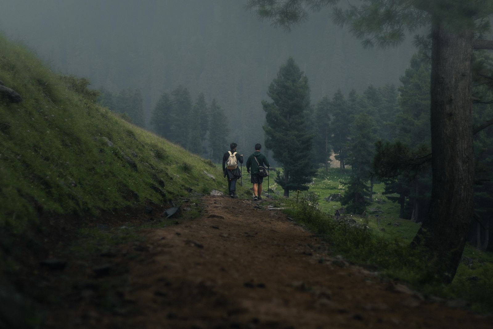
Sierra Calderona day hikes
The Sierra Calderona hiking guide covers the main mountain area in detail. The headline options for day hikes from Valencia:
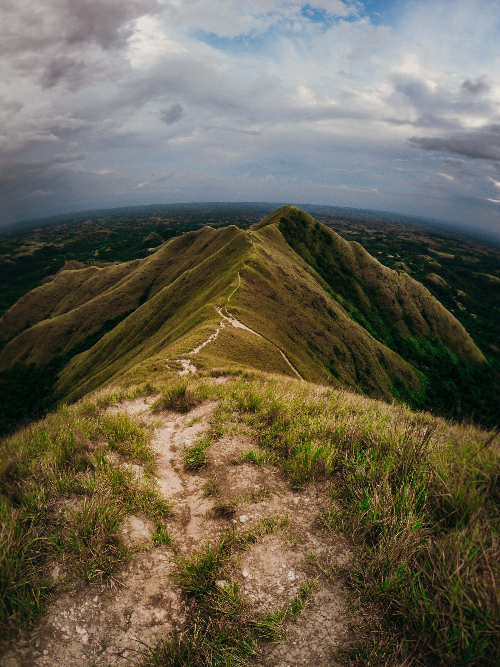
Garbí summit (the signature)
8-10 km circular from Mas de Mauro or Serra. 3-4 hours. The standard introduction to Sierra Calderona. Combines mountain views with the historic Cartuja de Porta Coeli monastery on the descent or as a side trip.
Gorgo summit (the highest)
12-15 km circular from Marines. 4-5 hours. The actual highest peak of the park (907 m). Less crowded than Garbí.
Olocau village + castle
Shorter walk combining the village of Olocau with the medieval castle ruin above. 2-3 km, 1-1.5 hours. Suitable for any fitness level. Best combined with lunch at one of the Olocau restaurants.
Sendero del Rodeno (sandstone trail)
10-12 km through the distinctive rust-red sandstone outcrops. 3-4 hours. The most photogenic single-hike option in the park.
Hiking-focused trips with multiple peaks across multiple days
Visitors planning to hike multiple regional peaks across 3-5 days — Garbí, Penyagolosa, Montgó, Sierra de Espadán summit, perhaps Cap de la Nau coastal cliffs — typically need rental car arrangements and accommodation flexibility. Arrival timing matters for the first-day hike. Valencia Airport (VLC) handles light and mid-size jets directly with FBO transfer to the city in 20 minutes — useful for groups wanting to be at a trailhead by 10:00 the morning after arrival. JetLuxe quotes the common European city pairs in 90 seconds.
Search Charter Flights →Inland mountain day hikes
The more dramatic and more challenging inland options, 90+ minutes drive from Valencia.
Penyagolosa summit
The signature inland mountain hike. 14-16 km circular with 550-650 m elevation gain. 4-5 hours hiking, plus 2 hours each way drive (130 km). Long day total: 11-13 hours. Suited to fit hikers wanting a serious mountain experience. The Penyagolosa hiking guide covers the route in detail.
Sierra de Espadán summit + cork-oak loop
Combine the Mount Espadán summit (1,099 m) with the cork-oak forest loops. 12-14 km total walking, 4-5 hours hiking, plus 1.5 hours each way drive. The Sierra de Espadán guide covers the area in detail.
Hoces del Cabriel Cuchillos circuit
Day combining the Cuchillos viewpoints with the Ruta de los Cuchillos circular hike (8-10 km, 3-4 hours). 1.5 hours each way drive. Combines well with afternoon Utiel-Requena wine tasting. The Hoces del Cabriel guide covers the canyons in detail.
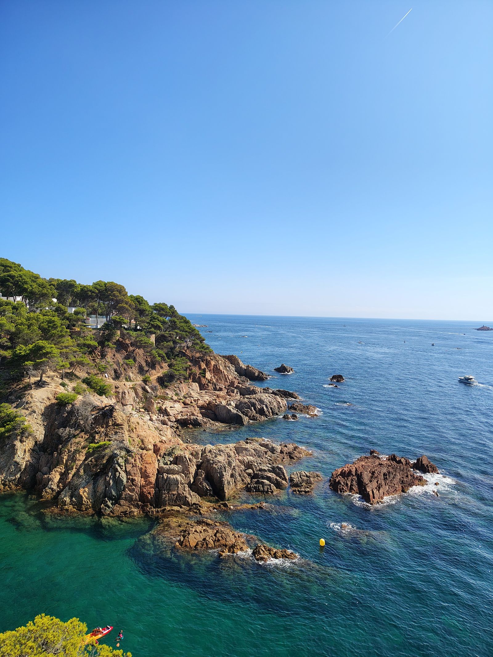
Coastal cliff day hikes
The Marina Alta coast, 95-115 km south of Valencia, offers some of the most dramatic coastal hiking in mainland Spain. The Montgó and Marina Alta hiking guide covers the area in detail.
Cap de Sant Antoni lighthouse
Short coastal walks from the lighthouse parking near Jávea. 0.5-3 km variable. Suitable for any fitness. Particularly photogenic at sunset. The easiest dramatic coastal option for visitors with limited time or fitness.
Montgó summit (Jávea)
The 753 m coastal mountain rising directly from the sea. 6-7 km return, 3-4 hours, moderate-hard. The classic Marina Alta peak experience.
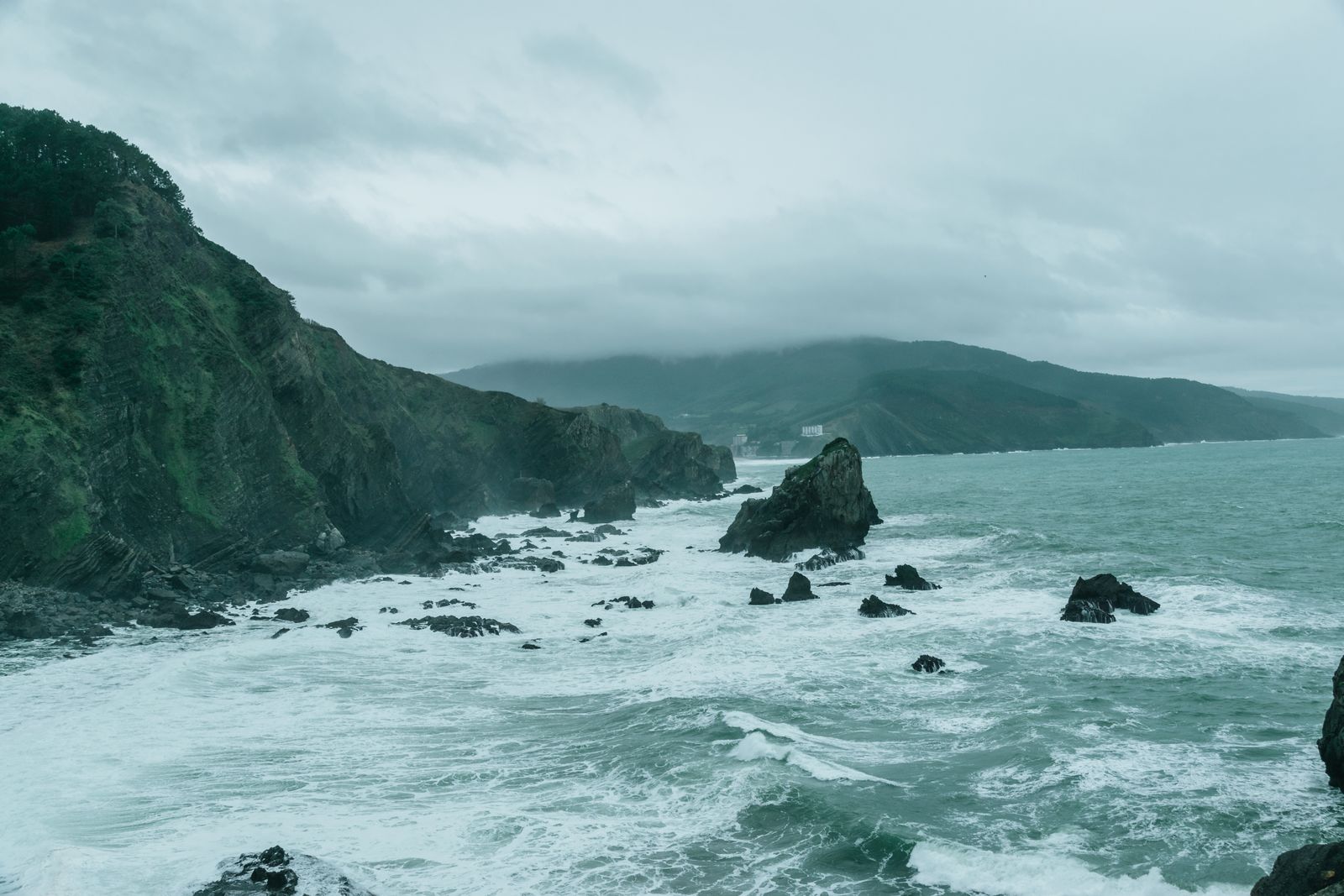
Cap de la Nau circular
The southernmost dramatic cape, with circular walks from the lighthouse or Granadella beach. 4-8 km variable. Moderate. Spectacular sea cliffs and offshore views.
The Cap de la Nau to Portitxol traverse
The full coastal traverse with multiple coves. 12-15 km, 5-6 hours. Hard. Best in spring or autumn; not recommended in summer heat.
Transport, kit, when to start
Transport options
- Self-drive rental car — most flexible option. €40-€80 per day. Necessary for most non-city hikes.
- Guided tour groups — €50-€140 per person depending on duration and inclusions. The right choice for first-time visitors or those uncertain about route navigation.
- Public transport — limited but workable for select hikes (Albufera, El Saler, Bétera-area Sierra Calderona).
- Private guide with transport — €200-€400 per day for groups of 2-6. The most flexible non-self-drive option.
Standard kit for Valencia day hikes
- Hiking boots or sturdy trainers — depending on the route. Boots for mountain hikes, trainers for coastal and beach options.
- 20-30 litre daypack — for water, snacks, layers.
- Water capacity — 1.5-3 litres depending on route and season.
- Sun protection — hat, sunglasses, sunscreen.
- Layers — Mediterranean climate but with temperature variation, particularly on the mountain hikes.
- Rain gear — lightweight; can save the day in autumn or winter.
- Phone with GPS — Wikiloc, Komoot, AllTrails all have good Valencia regional coverage.
- Basic first-aid — blister care, painkillers, antihistamines.
When to start
- Summer: Trailhead by 07:30; finish hiking by 13:00 to avoid afternoon heat.
- Spring/Autumn: Trailhead by 09:30-10:30; comfortable temperatures throughout the day.
- Winter: Trailhead by 09:30-10:00; shorter daylight (sunrise 08:00, sunset 17:30) limits the hiking window.
Building a hiking-focused Valencia trip
Three working patterns for hiking-focused Valencia visits:
The single-hike addition (4-5 day Valencia trip)
One day allocated to hiking during a city-focused trip. Sierra Calderona Garbí summit is the standard choice — accessible, varied, and gives a real outdoor experience without committing the whole trip. Total cost €60-€120 per person for the hike day.
The hiking-and-food weekend (3-4 days)
Two hikes plus the city food scene. Day 1: arrival, city food. Day 2: Sierra Calderona day hike + village lunch. Day 3: Hoces del Cabriel + Bobal wine tasting OR Sierra de Espadán + olive oil tasting. Suited to balanced trips wanting both outdoor and food experiences. Total cost €400-€800 per person.
The hiking-focused week (6-7 days)
Multiple hikes covering varied terrain. Possible structure: 2 days in central Valencia (city food + Albufera), 2 days in Marina Alta (Montgó + coastal cliffs), 2 days in Castellón mountains (Penyagolosa + Sierra de Espadán), 1 day in Utiel-Requena (Hoces del Cabriel + wine). Suited to outdoor-focused trips where hiking is the main activity. Total cost €1,200-€2,500 per person depending on accommodation and meals.
The wider context of Valencia's hiking culture sits alongside the Valencia running routes guide (for road and trail running), the Valencia mountain biking guide (for the MTB scene), and the Camino de Santiago de Levante guide (for the pilgrimage walking tradition).
Valencia in 2026 is one of the most under-recognised hiking gateways in Spain — comparable in option-density to better-known cities like Granada or Bilbao, but still without the international hiking-tourism profile those destinations have developed. For visitors who want to combine the famous Valencia city food and beach culture with serious outdoor experiences, the regional hiking options reward the trip.
Common questions
Depends on what you're looking for. For the easiest accessible mountain experience: the Garbí summit in {internal('valencia-sierra-calderona-hiking-guide-2026', 'Sierra Calderona')} (45-60 minutes by car, 8-10 km hike, 3-4 hours total). For the dramatic coastal cliffs: the {internal('valencia-montgo-marina-alta-hiking-guide-2026', 'Cap de Sant Antoni and Montgó area')} (95 km drive, multiple route options). For the easy nature experience: the Albufera and El Saler coastal walks (15-20 minutes from the city). For the most-iconic mountain experience: {internal('valencia-penyagolosa-hiking-guide-2026', 'Penyagolosa')} (2 hours drive, but a serious mountain summit). For first-time visitors with a single hike in the trip, the Sierra Calderona Garbí summit is the right introduction — accessible, varied, and gives a real mountain experience.
Yes, for a limited range of options. The Turia Gardens (within the city) accommodates the easiest walks. The Albufera and El Saler can be reached by bus 25 (around 30 minutes from the city centre). Bétera (southern edge of Sierra Calderona) is accessible by metro line 1 — from there, taxis or further buses reach the closer trailheads. Most other hiking options require a car (rental from €40/day) or guided tour (€50-€100 per person). For car-free visitors, the practical hiking options are: Turia Gardens walks, El Saler pine forest, Albufera shore walks, and the lower Sierra Calderona routes from Bétera. The more dramatic destinations (Penyagolosa, Hoces del Cabriel, Montgó) require own transport or guided tours.
Variable based on the choice. Easy (suitable for any fitness): Turia Gardens walks, Albufera coastal walks, Cap de Sant Antoni lighthouse walks. Around 2-5 km on flat or gently rolling terrain. Moderate (regular walker fitness): Sierra Calderona main routes (Garbí summit, etc.), Hoces del Cabriel Cuchillos viewpoint walk, Cap de la Nau Granadella circular. 6-10 km with moderate elevation gain. Hard (regular hiker fitness): Penyagolosa summit, Montgó summit, full Cap de la Nau coastal traverse. 12-16 km with significant elevation gain. Visitors of any fitness can find appropriate options; honest self-assessment matters.
October to May for most options. Spring (March-May) is the strongest single window for most hikes — wildflowers, mild temperatures, longer daylight, lower crowds. Autumn (September-November) is the second strongest, particularly for the inland routes. Summer (June-August) requires early-morning starts due to heat (30-38°C inland); the {internal('valencia-montgo-marina-alta-hiking-guide-2026', 'coastal Marina Alta')} routes remain comfortable due to sea breezes. Winter (December-February) is mild for the lower elevation routes (Albufera, El Saler, lower Sierra Calderona) but the higher peaks (Penyagolosa) can have snow and ice requiring winter mountaineering equipment. The single best window across all hike types: late April.
Yes — most day-hike options combine naturally with food or wine experiences. Sierra Calderona pairs with traditional inland village restaurants (Olocau, Náquera, Serra). Hoces del Cabriel combines naturally with {internal('valencia-bobal-utiel-requena-wine-guide-2026', 'Bobal wine tasting in Utiel-Requena')}. Montgó and Marina Alta combine with the {internal('valencia-mistela-moscatel-sweet-wine-guide-2026', 'Marina Alta sweet wines')}. Sierra de Espadán combines with {internal('valencia-olive-oil-aoct-guide-2026', 'olive oil tasting')}. Albufera combines naturally with the rice-paddy lunch tradition at El Palmar. The standard pattern: morning hike (3-5 hours), village lunch (1.5-2 hours), afternoon food/wine activity (1-3 hours), return to Valencia. Full days but well-paced.
Yes — multiple operators run guided day hikes with English-speaking guides. Cost: €40-€90 per person for a half-day guided hike with transport; €70-€140 per person for a full-day guided experience. The main operators include the Valencia Mountain Enthusiasts (regular weekend group hikes for resident expats and visitors), several adventure-tour companies running scheduled day tours, and private guides for bespoke experiences. For first-time visitors uncertain about navigation or unfamiliar with the trails, the guided option is meaningfully better than independent hiking. Group sizes typically 6-12 hikers.
Sponsored · Affiliate linkOutdoor-focused city visits work better with flexible arrivals. JetLuxe handles private charter into Valencia (VLC).
Plan Your Arrival →