Hoces del Cabriel Canyons Guide 2026: The Honest Adventurer's Manual
The Hoces del Cabriel — the dramatic limestone gorges carved by the Cabriel river west of Valencia — are one of the region's most visually striking but least-visited natural areas. The Natural Park covers around 32,000 hectares of canyons, ravines, and high plateau, with the signature 'Cuchillos' (Knives) rock formations creating one of Spain's most photogenic landscapes. The honest 2026 guide — hiking, rafting, when to visit, and how to combine with the Utiel-Requena wine region.
Adventure-sport weekend trips
Adventure-sport weekend trips — rafting, kayaking, canyoning — work best when arrival timing preserves the early-morning activity slots that adventure operators run. Valencia Airport (VLC) handles light and mid-size jets directly with FBO transfer to the city in 20 minutes. JetLuxe quotes the common European city pairs in 90 seconds.
Search Charter Flights →Hoces del Cabriel in context
The Hoces del Cabriel is one of inland Spain's most under-recognised natural wonders — dramatic enough to be a national-park-level landscape but quiet enough that few tourists ever see it. The headline facts:
- Location: Inland highlands west of Valencia, where Valencia province meets Cuenca and Albacete provinces. About 95 km from Valencia city.
- Park area: Approximately 32,000 hectares of protected territory.
- Declared: Natural Park status granted in 2005.
- Main geological feature: The dramatic limestone canyons carved by the Cabriel river over millions of years.
- Signature formations: The Cuchillos (Knives) — vertical limestone fingers rising 50-100 m from the canyon floor.
- River: Río Cabriel — a major tributary of the Júcar (Xúquer) river that flows to Valencia province and ultimately the Mediterranean.
- Adventure-sport activities: Rafting (popular), kayaking, canyoning, climbing, swimming.
- Hiking infrastructure: Multiple marked trails ranging from easy 2 km walks to 15+ km canyon descents.
- Cultural connection: Adjacent to the Utiel-Requena wine region, making canyon-and-wine day trips a natural combination.
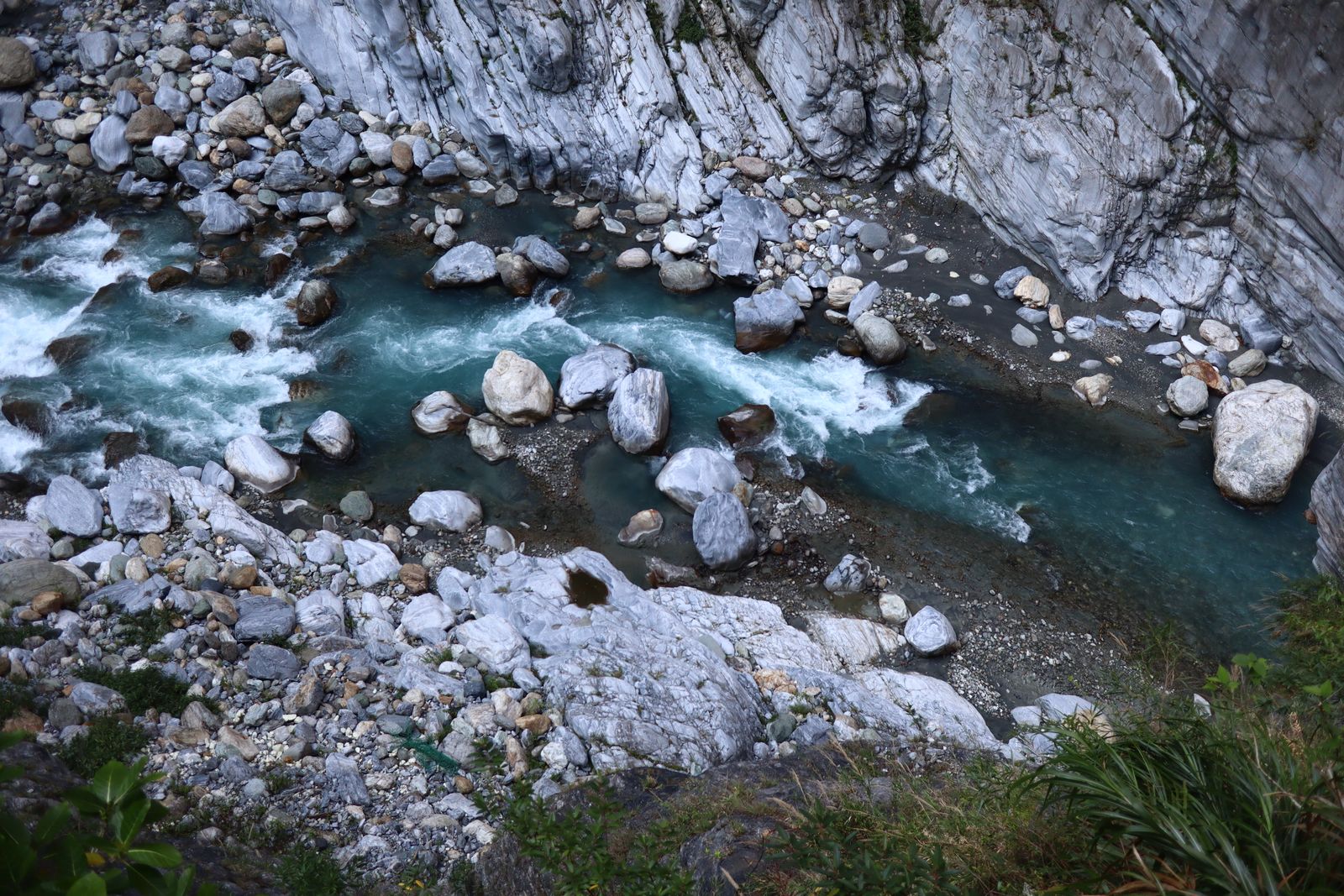
The river and the geology
The Cabriel river has carved its course through soft limestone over millions of years, exposing the underlying rock strata. The tilted geological strata — formed when tectonic forces lifted and tipped what had been horizontal sedimentary rock — created the distinctive Cuchillos formations: where harder limestone layers stand up as vertical knife-like ridges, while softer layers eroded away. The result is a landscape unlike anywhere else in eastern Spain — closer in character to the slot canyons of the American Southwest than to typical Spanish mountain country.
The Cuchillos — signature formations
The Cuchillos are the visual signature of the Hoces del Cabriel. Understanding what makes them distinctive:
What the Cuchillos actually are
The Cuchillos (literally 'Knives' in Spanish) are vertical limestone strata that have been rotated by tectonic forces to stand nearly vertical, then carved by the river into isolated finger-like ridges. The technical geological term is 'crestones' (vertical ridges) — but the local name reflects their dramatic blade-like appearance. They rise 50-100 m vertically from the surrounding plateau and canyon floor, with the river often winding between them.
The Tablas de los Cuchillos viewpoint
The single best-known viewpoint is the Tablas de los Cuchillos, accessible from a small parking area near Villargordo del Cabriel. From the parking, a short walk of 800 metres leads to a dramatic overlook with the Cuchillos visible directly below. Photogenic in any light but particularly striking at late-afternoon golden hour when the limestone glows orange.
Other viewpoints
- Mirador del Bicho — alternative viewpoint with a different angle on the canyon system. 1-2 km walk from the parking area.
- Mirador de la Pedriza — higher elevation viewpoint with panoramic views across the wider park.
- Cinglos viewpoints — series of smaller viewpoints along the canyon rim, accessible from various small parking areas.
Photography notes
Best times for Cuchillos photography:
- Morning (08:00-10:00) — soft light from the east, the canyon walls catching the early sun.
- Golden hour (60-90 minutes before sunset) — the limestone glows orange-red, the strongest photogenic moment.
- Midday in winter — the low winter sun gives stronger shadows than summer's direct overhead light.
- After rain — the wet limestone has greater contrast and richer colour.
- Avoid summer mid-day — flat overhead light, hazy atmosphere, and uncomfortable hiking conditions.
Hiking trails worth knowing
The Tablas de los Cuchillos viewpoint walk (easy)
The standard visitor route. 2-3 km return from the parking area to the main Cuchillos viewpoint and back. Easy gradient on a well-graded path. 45-60 minutes. Suitable for all fitness levels. The right introduction for first-time visitors with limited time.
The Ruta de los Cuchillos (moderate)
The signature circular hike. 8-10 km loop combining several viewpoints, descending partway into the canyon, and returning via a different ridge. 3-4 hours. Moderate difficulty with some rocky sections but no technical scrambling. The right hike for fit walkers wanting the full Cuchillos experience.
The full canyon descent (hard)
Longer route descending all the way into the canyon and walking along the riverside for several kilometres. 12-16 km circular, 5-6 hours, moderate-hard difficulty. The descent involves some steep sections; the riverside walk crosses the river at some points (small fords). Best suited to experienced hikers in the spring/early autumn season; avoid in summer (heat) or after significant rain (river too high).
The Mirador del Bicho route (easy-moderate)
Alternative viewpoint route, less-visited than the Tablas. 4-5 km return, 1.5-2 hours, easy gradient. Different angle on the canyon system; less crowded.
The Cinglos circuit (moderate)
Circuit through the upland Cinglos area, with multiple smaller viewpoints. 6-8 km, 2-3 hours, moderate. The right option for visitors wanting solitude rather than the busy main viewpoints.
Village-to-village walks
Several traditional paths connect the small villages around the park — Villargordo del Cabriel, Venta del Moro, Caudete de las Fuentes. These walks combine rural scenery, traditional architecture, and canyon views. Varies 5-15 km depending on the specific route chosen.
| Trail | Distance | Time | Difficulty | Best for |
|---|---|---|---|---|
| Tablas Cuchillos viewpoint | 2-3 km | 45-60 min | Easy | First-time visitors, short stops |
| Ruta de los Cuchillos circular | 8-10 km | 3-4 hrs | Moderate | Standard half-day hike |
| Full canyon descent | 12-16 km | 5-6 hrs | Hard | Experienced hikers |
| Mirador del Bicho | 4-5 km | 1.5-2 hrs | Easy-moderate | Quieter alternative |
| Cinglos circuit | 6-8 km | 2-3 hrs | Moderate | Solitude seekers |
Rafting and water sports
The Cabriel river is one of the most-popular adventure-sport destinations in eastern Spain. Multiple operators run guided activities during the active season.
Rafting
The signature water activity. Standard rafting trips:
- Duration — 2-3 hours of active rafting, plus 30-45 minutes briefing and 30-45 minutes return.
- Distance — 8-12 km of river covered.
- Difficulty — Class II-III rapids (suitable for beginners and intermediate rafters, not extreme whitewater).
- Group size — typically 6-8 people per raft, multiple rafts per trip.
- Cost — €30-€55 per person for the standard group experience.
- Inclusions — wetsuit, helmet, life jacket, paddle, instruction, guide on each raft, transport from staging area.
- Season — April to October, with the strongest flows April-June from spring snowmelt and rain. July-August have lower flows but warmer water; September-October moderate flows.
Kayaking
For more experienced paddlers, kayaking the Cabriel offers a more independent experience. Operators rent single and tandem kayaks; guided kayak tours are also available. Cost €25-€60 per person depending on rental vs guided format. Suitable for paddlers with prior kayaking experience.
Stand-up paddleboarding (SUP)
SUP on the calmer sections of the Cabriel is increasingly popular. Operators run SUP rentals and instructional sessions. €20-€40 per session. Best on the slower upper sections of the river where the current is gentler.
Canyoning
The smaller tributaries and side canyons offer canyoning opportunities — descending with ropes through narrow gorges with waterfalls and natural pools. Half-day canyoning trips €50-€85 per person; full-day €80-€130. Operators provide all technical equipment.
Swimming
Multiple natural pools along the river offer swimming in calmer sections. The most-popular swimming spots — near Villargordo del Cabriel and Venta del Moro — get busy on summer weekends. Water temperatures: cool but swimmable May-October (18-23°C), cold November-April.
Climbing
The limestone walls of the canyons offer climbing routes at various grades. Most climbing is on bolted sport routes; the longer multi-pitch traditional routes are for experienced climbers only. Several climbing schools operate in the area; guided climbing sessions run €60-€120 per person.
Adventure-sport tour groups with technical kit
Adventure-sport tour groups travelling with technical kit — climbing rope, helmets, harnesses, drysuits, technical packs — frequently exceed commercial baggage allowances. For groups of 4+ doing a Hoces del Cabriel weekend with multiple activities, the kit volume becomes meaningful. Valencia Airport (VLC) handles light and mid-size jets directly with FBO transfer to the city in 20 minutes — technical kit travels as standard cargo. JetLuxe quotes the common European city pairs in 90 seconds.
Search Charter Flights →The surrounding villages
Several small villages around the park offer accommodation, food, and the practical infrastructure for visits:
Villargordo del Cabriel
The main village adjacent to the Cuchillos viewpoints, around 450 residents. Small historic centre, several restaurants, a couple of small inns. The natural base for visitors. The village is on the route of the Camino de Santiago de Levante — pilgrims pass through Villargordo on stage 4-5 of the route from Valencia.
Venta del Moro
Slightly larger village (around 1,200 residents) 15 km from the main park. Traditional inland Castilian-style architecture, several restaurants serving traditional inland cuisine. Useful as an alternative base for larger groups requiring more accommodation than Villargordo can provide.
Requena
The largest town in the wider area (population around 20,000), 25 km from the park. Substantial historic centre, full accommodation options including small hotels and rural-tourism inns, multiple restaurants, and the centre of the Utiel-Requena wine region. Worth combining Hoces del Cabriel with Requena and one or two bodega visits for a full day or weekend.
Other villages
- Caudete de las Fuentes — small village in the wine country, with the Camino de Levante passing through.
- Cofrentes — further west, with thermal baths and a historic castle.
- Iniesta — across the border in Albacete province, with a notable historic centre.
Getting there and access
By car
The only realistic access. From Valencia city:
- To Requena — A-3 motorway west, 60 minutes, around 70 km.
- To Villargordo del Cabriel — A-3 to Requena, then CV-50 to Villargordo. About 95 km total, 1 hour 30 minutes.
- To the Tablas de los Cuchillos viewpoint — from Villargordo, follow signs to the parking area, additional 5-10 minutes.
Parking and access
Free parking at all the main viewpoints and trailheads. Capacity is limited at the most-popular Tablas de los Cuchillos parking (40-60 cars); arrive by 10:30 on weekends in peak season to secure parking. Overflow parking is along the access roads; walk an extra 10-15 minutes from the further parking spots.
Adventure operator staging areas
Most adventure operators have their own staging areas where they hand out kit, brief visitors, and arrange transport to the river. Standard process: meet at the operator's base in Requena, Villargordo or Venta del Moro 30-45 minutes before activity start; equipment fitting, briefing, transport to the river launch; activity 2-3 hours; transport back to the base; total 4-5 hours from base to base.
Mobile signal and safety
Mobile signal is patchy in the canyons — good on the upper plateau, weak in the deeper canyon sections. Spanish emergency number 112. Most adventure activities have professional guides with emergency procedures. For independent hikers on the longer canyon routes, file a route plan and carry extra supplies.
When to visit
| Season | Hiking | Rafting | Combined day-trip |
|---|---|---|---|
| March-April | Excellent | Strong flows | Strong window |
| May-June | Excellent | Peak season | Best window |
| July-August | Too hot (32-38°C) | Warm water | Rafting only |
| September-October | Excellent | Moderate flows | Excellent window |
| November-February | Cool but workable | Closed | Hiking only |
The single best window: late April to mid-June, when all activities align — water flows strong, temperatures mild for hiking, longer daylight, wildflowers, and the canyons at their visual peak.
Planning a Hoces day trip
Three working patterns:
The single-day visit from Valencia
09:00 departure from Valencia, arrive Villargordo del Cabriel by 10:30, Tablas de los Cuchillos viewpoint walk (1 hour), short canyon hike (2-3 hours), lunch in Villargordo or Venta del Moro (1.5 hours), return to Valencia by 17:30-18:00. Cost €50-€100 per person.
The canyon + wine combination
09:00 departure, morning at Hoces del Cabriel (Cuchillos viewpoint + short hike, 3-4 hours), lunch in Requena, afternoon at one or two Utiel-Requena bodegas with tasting (2-3 hours), return to Valencia by 19:00-20:00. The full picture sits in the Bobal wine guide. Cost €100-€200 per person.
The adventure-sport weekend
2 nights based at Villargordo del Cabriel, Venta del Moro or Requena. Day 1: rafting in the afternoon. Day 2: longer hike (Ruta de los Cuchillos or full canyon descent), evening at the village. Day 3: kayaking or canyoning before return to Valencia. Suited to adventure-focused weekend trips. Total cost €300-€600 per person.
The wider context of inland Valencia natural areas sits alongside the Bobal wine guide (which covers the wine region adjacent to the park), the Camino de Santiago de Levante (which passes through Villargordo del Cabriel as part of stage 4-5), and the broader Valencia day hikes guide for context across other regional hiking options.
The Hoces del Cabriel in 2026 remains one of inland Spain's genuine secrets — a national-park-quality landscape with the visual drama of the American Southwest, accessible enough for day trips from Valencia, but quiet enough to feel discovered rather than packaged. For visitors willing to look beyond the obvious coastal destinations, the trip rewards the time.
Common questions
The Hoces del Cabriel Natural Park is located approximately 95 km west of Valencia city, in the inland highlands where Valencia province meets Cuenca and Albacete provinces. The park covers around 32,000 hectares of dramatic limestone canyon country, carved by the Cabriel river (a major tributary of the Júcar/Xúquer river). The main access points are via Requena (the largest nearby town) and the smaller villages of Villargordo del Cabriel, Venta del Moro and Caudete de las Fuentes. The park was declared a Natural Park in 2005, recognising both its dramatic landscape and its unusual ecology. Driving from Valencia city takes about 1 hour 30 minutes via the A-3 motorway.
The Cuchillos (literally 'Knives') are the signature rock formations of the Hoces del Cabriel — vertical limestone strata that have been raised by tectonic forces into near-vertical knife-like ridges, then carved by the river into dramatic isolated fingers. The formations rise 50-100 m vertically from the surrounding plateau, with the river winding between them. The best-known and most-photographed formation is the 'Tablas de los Cuchillos' viewpoint near Villargordo del Cabriel, accessible by a short walk from the road. The Cuchillos are one of the most distinctive geological features in eastern Spain and a key reason the park earned its protected status.
Yes — the Cabriel river is one of the most-popular rafting destinations in eastern Spain. Several operators run guided rafting trips during the spring-summer season (April-October), with the strongest water levels in April-June. Standard 2-3 hour rafting trips cover 8-12 km of river with Class II-III rapids, suitable for beginners and intermediate rafters. Cost €30-€55 per person for the standard group experience. Operators include Aventura Cabriel, Cabriel Aventura and several others based in Requena, Villargordo del Cabriel and Venta del Moro. Kayaking, canyoning, and stand-up paddleboarding are also available. Most operators include all equipment, transport from staging areas, and guide.
Three main options. (1) The Tablas de los Cuchillos viewpoint walk — short 2-3 km return from the parking area to the dramatic canyon overlook. Easy, suitable for all levels. (2) The Ruta de los Cuchillos circular — 8-10 km loop combining several viewpoints and descending partway into the canyon. Moderate difficulty, 3-4 hours. (3) The full Cabriel Canyon descent — longer route descending all the way into the canyon and walking along the riverside. 12-16 km circular, 5-6 hours, moderate-hard. Other shorter walks include the Mirador del Bicho viewpoint route, the Cinglos area trails, and various village-to-village walks combining historic sites with canyon views.
Yes — this combination is one of the most-rewarding day-trip patterns from Valencia. The Hoces del Cabriel Natural Park sits just west of the Utiel-Requena wine region, meaning a single day trip can include both. The standard combined pattern: morning visit to the Cuchillos viewpoints and a short canyon walk (2-3 hours), lunch at a Requena or village restaurant, afternoon visit to one or two bodegas with tasting (2-3 hours), return to Valencia. Total day trip 10-12 hours, around €100-€200 per person for car, lunch, tastings and incidentals. The {internal('valencia-bobal-utiel-requena-wine-guide-2026', 'Bobal wine guide')} covers the wine region in detail.
Different activities have different optimal seasons. Hiking: March-June and September-November (mild temperatures, longer daylight). Rafting and water sports: April-July (highest water levels and warmest weather suitable for getting wet). Wine combined with canyons: October-November (autumn vineyards, post-harvest cellars, mild temperatures). Photography: late October (autumn vegetation, lower sun angles, clear post-summer atmosphere). Avoid July-August for hiking (extreme heat in the exposed canyons) and avoid winter (December-February) for rafting (cold water, lower flows). The single best window: late April to mid-June, when all activities align.
Sponsored · Affiliate linkAdventure-sport trips work better with morning-arrival flexibility. JetLuxe handles private charter into Valencia (VLC).
Plan Your Arrival →