Montgó and Marina Alta Coastal Hiking Guide 2026: The Honest Walker's Manual
Montgó (753 m) is the dramatic coastal mountain rising directly out of the Mediterranean between Dénia and Jávea — a near-vertical limestone massif that has been a landmark for sailors since Roman times, and one of the Valencian Community's most visually distinctive hiking destinations. Combined with the Cap de la Nau and Cap de Sant Antoni cliffs, the Marina Alta coast offers some of the most dramatic coastal walking in mainland Spain. The honest 2026 guide.
Marina Alta coastal trips
Marina Alta trips — Dénia, Jávea, Calp, the wine villages of the Vall de Pop — work as either extensions from Valencia or standalone destinations. For visitors based further north in Europe, arrival into Valencia (VLC) or Alicante (ALC) both work, with a 1-hour drive to the Marina Alta. TimeFlys handles light and mid-size jets into both airports directly with FBO transfer, and quotes the common European city pairs quickly.
Search Charter Flights →Montgó and the Marina Alta in context
The Marina Alta is the northernmost district of Alicante province — culturally and geographically continuous with southern Valencia province, but administratively part of Alicante. The area is one of the most distinctive coastal landscapes in mainland Spain:
- Location: Between Dénia (north) and Calp (south), with Jávea and the inland Vall de Pop villages in between.
- Distance from Valencia: 90-105 km, 1 hour 15 minutes to 1 hour 30 minutes drive.
- Distance from Alicante: 100-115 km, 1 hour 30 minutes drive.
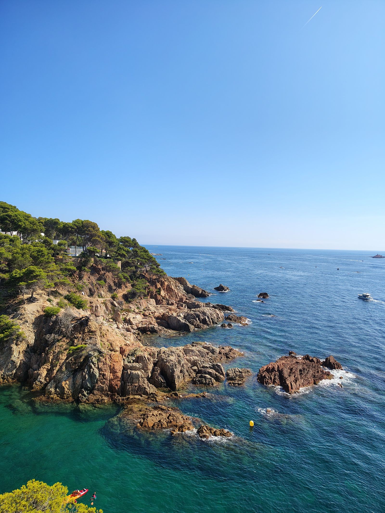
- Defining features: The Montgó massif (753 m, rising directly from the sea), the Cap de Sant Antoni and Cap de la Nau coastal capes, the protected coastal coves (Granadella, Portitxol, Ambolo), and the inland wine villages of the Vall de Pop.
- Climate: Among the most stable Mediterranean climates in mainland Europe — mild winters (10-16°C daytime in January), warm summers (28-32°C in August), and minimal seasonal extremes.
- Hiking infrastructure: Extensive marked trail network including PR-CV (regional short routes), the GR-7 long-distance trail, and various local routes.
- Tourism context: Strong international tourism (particularly British, German, Dutch and Belgian expats), particularly around Jávea. The Marina Alta is more international than other parts of inland Valencia province.
Why the Marina Alta works for hiking
Three things make the Marina Alta particularly appealing as a hiking destination:
- Year-round walkability. Unlike inland mountain areas that close to summer hiking due to heat, the Marina Alta coast has reliable sea breezes that keep the temperature 3-5°C cooler than inland Spain. Summer hiking is possible (early morning) where it isn't at Penyagolosa or even the Sierra Calderona.
- Variety of difficulty. From flat coastal walks to dramatic mountain ascents within a 15-minute drive of each other, the area accommodates all hiking levels.
- Combination potential. Hiking combines naturally with beach, food (the Marina Alta has a serious food scene), and wine (the sweet wines of Marina Alta).
Climbing Montgó — the summit route
Montgó is the defining mountain of the Marina Alta — a 753 m limestone massif that rises near-vertically from the coast between Dénia and Jávea. The standard summit ascent:
Standard route — PR-CV 355
- Trailhead: Camí de la Plana parking area on the southern flank, between Dénia and Jávea.
- Distance: 6-7 km return.
- Elevation gain: Approximately 650 m.
- Time: 3-4 hours including summit time.
- Difficulty: Moderate to moderate-hard. Well-marked path; some scrambling on the upper rocky sections.
- Footwear: Hiking boots recommended for the loose limestone scree on the upper sections.
- Water: 1.5-2 litres per person. No water sources on the route.
Stage 1: Pine forest (km 0-1.5)
The lower section ascends through Mediterranean pine forest on a well-graded path. Gentle gradient (50-100 m elevation gain per km). Allow 45-60 minutes.
Stage 2: Mediterranean scrub (km 1.5-3)
Above the tree line, the trail enters Mediterranean scrub (garriga) — rosemary, thyme, dwarf palmetto, kermes oak. The path becomes steeper and rockier. The Mediterranean comes into view to the east. Allow 45-60 minutes.
Stage 3: Summit ridge (km 3-3.5)
The final approach involves moderate scrambling on exposed limestone. The path is marked but the route requires using hands occasionally on steeper sections. The summit cross is visible from below; the final 100 m is the most exposed. Allow 20-30 minutes.
The summit views
From the summit:
- East: The Mediterranean and the Illa del Portitxol offshore. On clear days, Ibiza is visible 90 km east.
- South: The southern Marina Alta coast — Jávea, the Cap de la Nau, and the unmistakable Penyal d'Ifac at Calp.
- West: The inland Marina Alta — the Vall de Pop villages, the surrounding mountains.
- North: Dénia, the coastline north toward Gandía and Valencia.
The descent
Return the same way. The descent is meaningfully harder on the knees than the ascent due to the loose limestone; trekking poles help significantly. Allow slightly less time than the ascent (1-1.5 hours).
Alternative routes
- From Dénia (north face): Longer (8-9 km) but with different scenery. PR-CV 354 ascends from the northern slopes.
- The full traverse: Combine the ascent from one side with descent on the other, requiring two-car logistics or a return walk on the lower roads.
- The summit ridge variant: Once at the summit, walk along the ridge for 20-30 minutes for additional viewpoints.
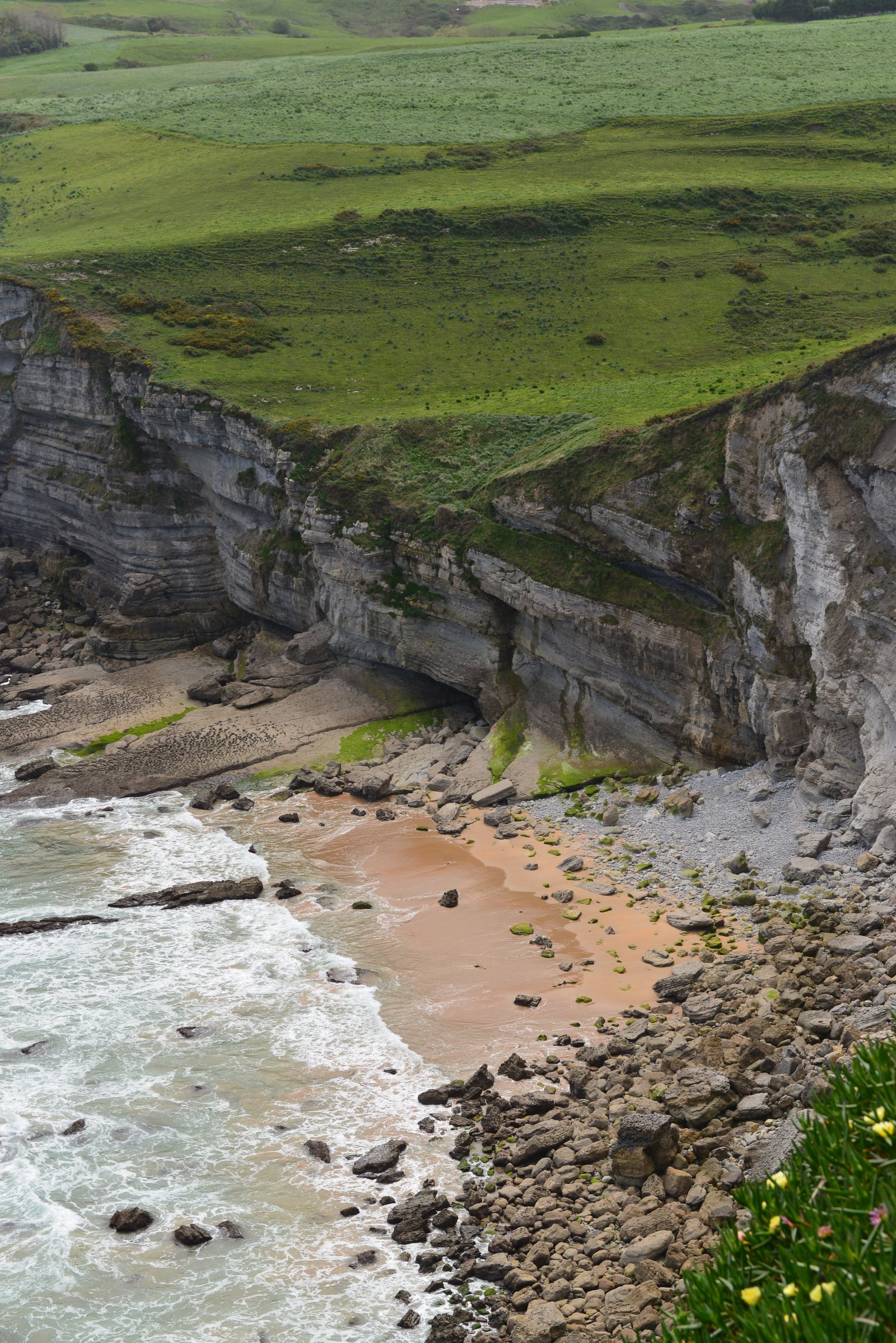
Cap de Sant Antoni — the coastal cliff walk
Cap de Sant Antoni is the dramatic coastal promontory on the northern flank of Montgó. The cape rises 175 m directly above the sea, with a working lighthouse at the highest point. The cape's walking options:
The lighthouse short walk
Drive to the Cap de Sant Antoni lighthouse car park (free, capacity 30-40 cars). From the car park, several short walks of 0.5-2 km lead to clifftop viewpoints. The northern viewpoint gives panoramic views over Dénia and the coastline toward Valencia. The southern viewpoint gives views over Jávea and the Marina Alta coast. Both walks are easy and suitable for any fitness level.
The Cap de Sant Antoni + Montgó link
A circular route combines the cape with a partial ascent of Montgó. Distance 8-10 km, with 400-500 m elevation gain. Moderate difficulty. Around 4-5 hours. Gives the cape views plus a taste of the Montgó terrain without committing to the full summit climb.
The Cova Tallada cave walk
From the cape area, a coastal trail descends to the Cova Tallada — a remarkable medieval-era cave excavated into the cliff face, accessible from the sea or via a steep coastal path. Distance 4-5 km return; some scrambling. The cave was used historically for stone quarrying; the chambers extend several metres into the cliff. Worth combining with a swim in the adjacent coves (in summer).
Sunset at the lighthouse
Cap de Sant Antoni is one of the most-photogenic sunset spots in the Marina Alta. The lighthouse sits at 175 m elevation directly above the Mediterranean. Sunset times vary by season — late May through July gives the latest sunsets (around 21:30); November-January the earliest (around 17:45). The 60-90 minutes before sunset are the strongest photogenic window.
Cap de la Nau and the southern cliffs
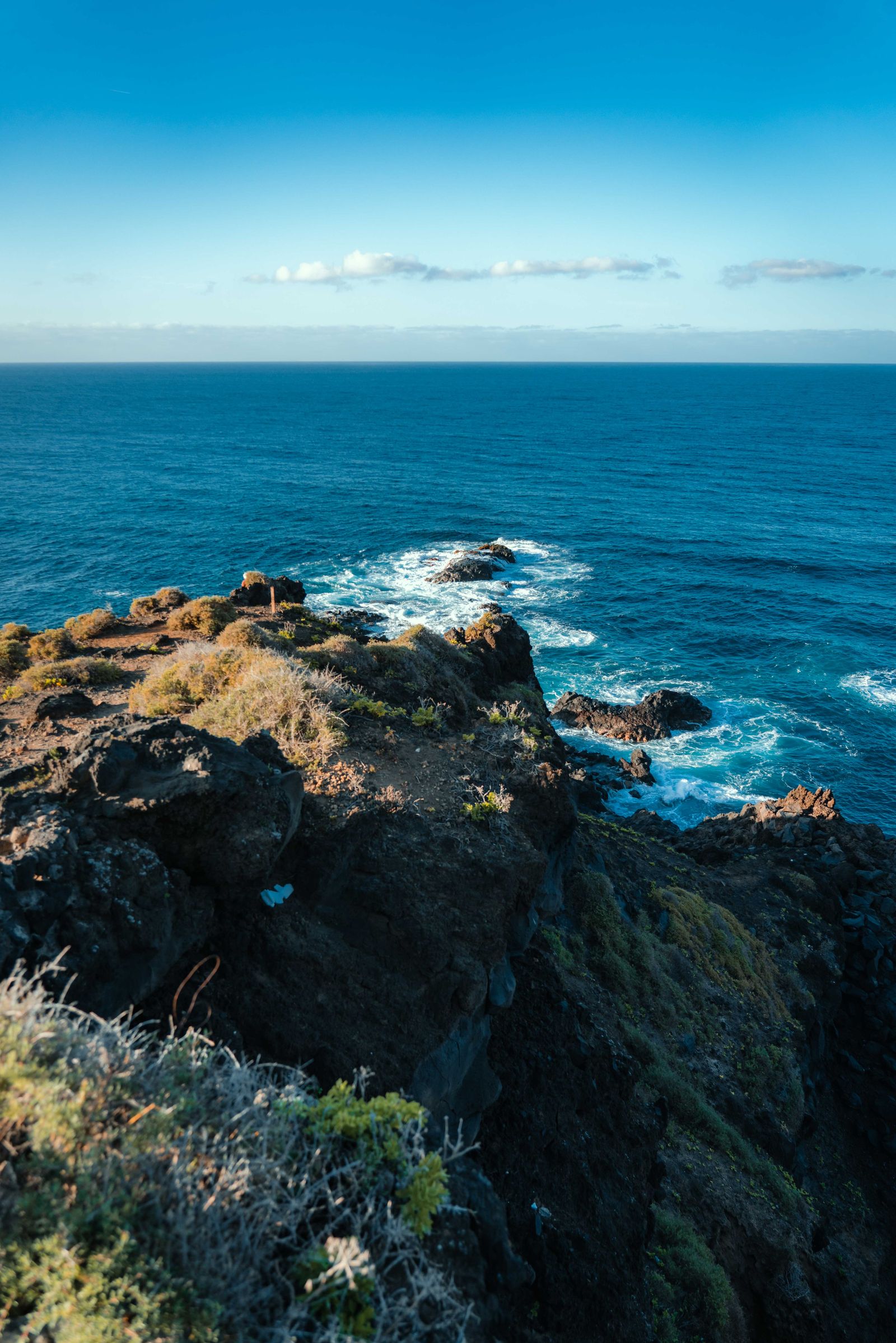
Cap de la Nau (Cabo de la Nao in Spanish) is the southernmost dramatic cape of the Marina Alta, south of Jávea. The cape includes Spain's nearest point to the Balearic Islands (Ibiza is visible 79 km away on clear days), a working lighthouse, dramatic clifftop walks, and access to several small coves and beaches.
The Cap de la Nau lighthouse short walk
Drive to the Cap de la Nau lighthouse car park (free, busy on summer weekends). Short 0.5-1 km walks lead to clifftop viewpoints in multiple directions. The southern viewpoint is the most-photographed — vertical limestone cliffs falling 150 m directly to the Mediterranean.
The Granadella circular
From the Granadella beach area, a circular route combines beach walking with clifftop ascent. 6-8 km, with 300-400 m of elevation gain. Moderate difficulty. The route passes the dramatic Cova del Llop Marí (Sea Wolf Cave) and several smaller coves.
The Cap de la Nau to Portitxol coastal traverse
The long coastal walk — from Cap de la Nau lighthouse, north along the clifftops to Granadella beach, then continuing north to the Portitxol cove. Total 12-15 km, 5-6 hours. Significant up-and-down on the clifftops, with multiple drops to coves and re-ascents. Suited to experienced hikers in the cooler months; not recommended in summer heat.
The Portitxol cove and offshore island
Portitxol is a protected cove with crystal-clear water, popular for swimming and snorkelling. The offshore Illa del Portitxol is visible from the cove and from Montgó summit. Worth combining the clifftop walk with a swim and lunch at the small bar at the cove (open seasonally).
| Route | Distance | Time | Difficulty | Best for |
|---|---|---|---|---|
| Montgó summit | 6-7 km | 3-4 hrs | Moderate-hard | Classic peak experience |
| Cap Sant Antoni lighthouse | 0.5-2 km | 30-60 min | Easy | Sunset, families |
| Cap Sant Antoni + Montgó link | 8-10 km | 4-5 hrs | Moderate | Combining cape and mountain |
| Cova Tallada | 4-5 km | 2-3 hrs | Moderate | History + swimming |
| Cap de la Nau short walks | 0.5-1 km | 30-45 min | Easy | Quick visits, views |
| Granadella circular | 6-8 km | 3-4 hrs | Moderate | Coves + clifftops |
| Cap Nau to Portitxol traverse | 12-15 km | 5-6 hrs | Hard | Experienced hikers |
Reaching the trailheads from VLC or ALC
A car is effectively essential for the Marina Alta — the trailheads at Montgó, Cap de Sant Antoni and Cap de la Nau have no practical public transport. For visitors who would rather not drive straight after a flight, a pre-booked transfer from Valencia (VLC) or Alicante (ALC) to a Dénia or Jávea base removes the airport-collection friction at the start of the trip. GetTransfer confirms vehicle class, driver and timing against your arrival.
Book an Airport Transfer →Dénia, Jávea and the local bases
Dénia (population 45,000)
The largest town in the Marina Alta and the historical capital of the area. Strong points: the historic castle (Castell de Dénia, 11th century, with panoramic views), the busy fishing port and marina, the ferry connection to the Balearic Islands (regular sailings to Ibiza and Mallorca), the working-Spanish-town atmosphere, the substantial restaurant scene. Less polished than Jávea but more authentic. Best base for visitors who want a town atmosphere rather than a resort.
Jávea / Xàbia (population 28,000)
Smaller but more visibly oriented to international visitors. Strong points: the lovely historic old town (with Gothic church and well-preserved medieval streets), the family-friendly Arenal beach, direct access to the dramatic coastal walks, the substantial Anglo/German/Dutch expat population (meaning English is widely spoken). Three distinct areas: the historic old town, the port area (Aduanas), and the Arenal beach district. Best base for visitors focused on the coastal hiking and the international expat atmosphere.
Vall de Pop villages (inland)
For visitors wanting the Marina Alta combined with inland wine tourism, the Vall de Pop villages — Jalón (Xaló), Parcent, Lliber, Senija, Alcalalí — offer rural-tourism accommodation in the wine country. The Mistela and Moscatel sweet wine guide covers the wine context. 20-30 minutes drive inland from Dénia or Jávea.
Getting there, parking, when to start
By car
The realistic access option. From Valencia city:
- To Dénia: A-7 motorway south, exit 62, then CV-731. About 95 km, 1 hour 15 minutes.
- To Jávea: A-7 to exit 62, then CV-734 / CV-737 to Jávea. About 100 km, 1 hour 25 minutes.
- To Cap de Sant Antoni: Within Jávea, follow signs to the lighthouse. Additional 10-15 minutes from town centre.
- To Cap de la Nau: From Jávea, follow signs south to the lighthouse. Additional 15-20 minutes.
- To Montgó trailhead (Camí de la Plana): From Jávea or Dénia centres, 15-20 minutes drive on the smaller mountain roads.
By public transport
Limited options:
- By train and bus from Valencia: Train to Gandía, then bus to Dénia. Total journey 2.5-3 hours.
- By bus directly from Valencia: ALSA runs services to Dénia and Jávea (2-3 hour journey).
- By taxi from Valencia airport: €120-€180 each way; impractical for daily trips.
The complete absence of practical public transport to the trailheads themselves means a car is effectively essential for visitors wanting to hike. For airport-to-base logistics, the Valencia airport transfer guide covers the options in detail.
When to start hikes
- Summer: Start by 07:00. The Mediterranean sun is intense from 11:00; the upper Montgó has minimal shade.
- Spring/Autumn: Start by 09:00. Comfortable temperatures throughout the day.
- Winter: Start by 10:00. Short daylight means earlier finishes are needed.
When to hike Marina Alta
Marina Alta is one of the most-walkable areas in Spain year-round, but with seasonal variations:
| Season | Conditions | Verdict |
|---|---|---|
| January-February | 10-16°C, occasional rain, fresh greenery | Surprisingly good |
| March-April | 12-20°C, wildflowers, longer daylight | Excellent |
| May-June | 18-26°C, perfect conditions | Best window |
| July-August | 28-32°C, start early | Workable with early starts |
| September-October | 22-28°C, swimming still possible | Excellent |
| November-December | 14-18°C, occasional storms | Good for short walks |
The single best window: late April to mid-June. Wildflowers, mild temperatures, longer daylight, swimming becoming possible from May, and the Marina Alta still relatively quiet before the August peak season.
Planning a Marina Alta weekend
Three working patterns:
The day-trip from Valencia
Depart Valencia 07:30, arrive Montgó trailhead 09:30, climb Montgó (3-4 hours), lunch in Jávea 14:00, Cap de Sant Antoni viewpoint walk 16:00-17:30, return to Valencia by 19:30. €60-€120 per person.
The Marina Alta weekend (2 nights)
Stay 2 nights in Dénia or Jávea. Day 1: Montgó summit + Jávea old town. Day 2: Cap de Sant Antoni + Cap de la Nau coastal walks. Day 3: optional Vall de Pop wine tasting before return. Total cost €400-€800 per person depending on accommodation level.
The Marina Alta long-weekend (3-4 nights)
Multiple hikes, beach time, Vall de Pop wine tasting, sailing or boat trip from Dénia. The full Marina Alta experience. €700-€1,500 per person.
The wider context of the Marina Alta sits alongside the Marina Alta sweet wines (the inland Vall de Pop wine tradition), the Valencia day trips guide (which includes Marina Alta options), and the Valencia sailing guide (for boat-based exploration of the Marina Alta coast).
The Marina Alta in 2026 is one of the most-visually-distinctive coastal hiking areas in mainland Spain — dramatic limestone mountains rising directly from the Mediterranean, cliffs and capes, hidden coves, and the practical accessibility from Valencia or Alicante. For visitors wanting coastal hiking beyond the usual Costa Blanca beach destinations, the trip rewards the effort.
Common questions
The standard summit route starts at the Camí de la Plana parking area on the southern flank of the mountain, between Dénia and Jávea. From there, the marked trail (PR-CV 355) ascends through Mediterranean scrub and pine forest to a saddle, then climbs the rocky upper slopes to the summit at 753 m. Total distance 6-7 km return, with around 650 m of elevation gain. Allow 3-4 hours including summit time. The route is well-marked but the upper sections involve moderate scrambling on exposed limestone — not technical climbing, but requiring some confidence on rocky terrain. The summit gives spectacular views over the Marina Alta coast, including the offshore Illa del Portitxol, and across to the Penyal d'Ifac at Calp.
Montgó Natural Park (Parc Natural del Montgó) covers the mountain itself and the surrounding coastal area between the towns of Dénia (north) and Jávea (south), in the Marina Alta district of northern Alicante province. The park was declared in 1987, covering 2,117 hectares. The mountain rises near-vertically from the coast, reaching 753 m at the summit. The park boundary includes the mountain's slopes, the Cap de Sant Antoni promontory on the northern coast, and several smaller coastal features. From Valencia city, the park is approximately 95 km south via the AP-7 motorway, taking about 1 hour 15 minutes by car.
Cap de Sant Antoni is the dramatic coastal cape on the northern flank of Montgó, between Dénia and the Mediterranean. The cape features a working lighthouse, panoramic viewpoints over Dénia and the Costa Blanca, and a series of clifftop walks. The cape rises 175 m directly above the sea, with the lighthouse at the highest point. The Cap de Sant Antoni walking trails include short 1-2 km walks suitable for any fitness level, plus longer circuits combining the cape with sections of the Montgó mountain. The viewpoints are particularly photogenic at sunset, when the Mediterranean catches golden light to the east. Free parking near the lighthouse; the access road is paved and easy driving.
Variable — depending on which Cap de la Nau route you choose. Cap de la Nau (also Cabo de la Nao) is the southernmost dramatic cape of the Marina Alta, south of Jávea. Easy options: the short 2-3 km walks from the Cap de la Nau lighthouse parking, with panoramic viewpoints and minimal elevation change. Moderate options: the longer 6-8 km circular routes from the Granadella beach area, including some descent and re-ascent. Hard options: the full Cap de la Nau to Granadella to Portitxol coastal traverse, 12-15 km with significant up-and-down on the clifftops. All routes give dramatic ocean views; the choice depends on time and fitness. The shorter lighthouse-area walks are suitable for any visitor; the longer traverses require proper hiking fitness.
Both work; the choice depends on focus. Dénia is the larger town (around 45,000 residents), with more accommodation variety, a busy waterfront, the ferry port to the Balearic Islands, and direct access to the northern face of Montgó. Dénia atmosphere is more 'working Spanish town with tourists' than purely tourist resort. Jávea (Xàbia in Valencian, around 28,000 residents) is more visibly oriented to international visitors — Anglo and German expat populations significant — with a lovely historic old town separated from the modern beach areas. Jávea has better direct access to the Cap de Sant Antoni and the Cap de la Nau coastal walks. For first-time visitors focused on the coastal hiking, Jávea is the slightly stronger choice; for a more rounded Marina Alta experience including the inland villages and the ferry-port atmosphere, Dénia.
Yes — 95 km drive each way means a day trip is feasible. The standard pattern: depart Valencia 07:30-08:00, arrive at the trailhead by 09:30, climb Montgó (3-4 hours including summit), lunch in Jávea or Dénia (1.5 hours), short coastal walk at Cap de Sant Antoni (1-2 hours), return to Valencia by 18:30-19:30. Total day 11-12 hours. For visitors wanting more depth, an overnight stay in Dénia or Jávea is meaningfully more relaxed and allows multiple hikes over 2-3 days plus the local food experience including the Marina Alta sweet wines from the Vall de Pop inland.
Sponsored · Affiliate linkMarina Alta trips work well from VLC or ALC. TimeFlys handles private charter into both.
Plan Your Arrival →